MARINER 9 ORBITER CLOUD OCCURRENCE FROM IMAGING DATA SET
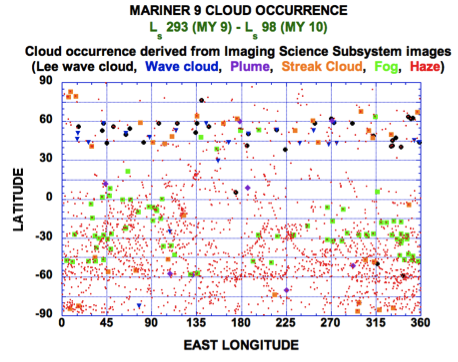
Above is shown a map presentation of several types of clouds within the martian atmosphere detected in images obtained with the Imaging Science System (ISS) onboard the Mariner 9 orbiter. Haze type clouds were most prominent during the Northern Winter through Northern Spring time interval covered by the Mariner 9 imaging.
The DATA contained within the Mariner 9 PDS cloud archive provide the location (latitude, longitude), time (Ls and time-of-sol), cloud type, and other quantitative aspects of the cloud occurrence and image conditions under which the cloud was detected. The data themselves are presented in tabular ASCII form in the mr9_clds.dat file within the DATA folder within the archive vomr_0001. The contents of the data file span the period Ls 293 MY 9 to Ls 98 MY 10. The contents of and structure of this data file are described in the file mr9_clds.lbl file which is also located within the DATA folder in the vomr_0001 archive. Within the DATA folder of the vomr_0001 archive you will also find a an ASCII data file (vo_clds.dat) containing cloud occurrence derived from Viking 1 and Viking 2 orbiter imaging (Ls 85 MY 12 - Ls 140 MY 14 for Viking Orbiter 1; Ls 107 MY 12 to Ls 116 MY 13 for Viking Orbiter 2); the structure of that file is the same as that of Mariner cloud occurrence file.
For information about the Mariner 9 cloud occurrence data set, click here
For information about the Mariner 9 mission, click here
For information about the Mariner 9 Imaging Science System (ISS) instrument, click here

