Menu: Skip within this page
![]() PDS: The Planetary Atmospheres Node
PDS: The Planetary Atmospheres Node
| Encounter* | URN | Start Time | Stop Time | Latitude | E(+/-180°) Longitude | W(0-360°) Longitude |
| T12-I | urn:nasa:pds:corsstpp:data_derived:corsstppt12i | 2006-03-19T00:05:16 | 2006-03-19T00:07:12 | -31.5 | 153.3 | 206.7 |
| T12-E | urn:nasa:pds:corsstpp:data_derived:corsstppt12e | 2006-03-19T00:20:20 | 2006-03-19T00:18:05 | -52.8 | 17.6 | 342.4 |
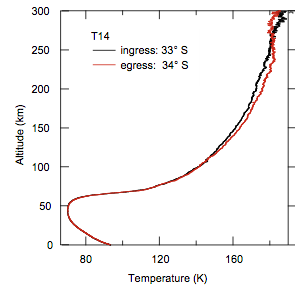
| T14-I | urn:nasa:pds:corsstpp:data_derived:corsstppt14i | 2006-05-20T12:11:31 | 2006-05-20T12:13:04 | -32.7 | -176.6 | 176.6 |
| T14-E | urn:nasa:pds:corsstpp:data_derived:corsstppt14e | 2006-05-20T12:25:49 | 2006-05-20T12:24:16 | -34.2 | 32.6 | 327.4 |
| T27-I | urn:nasa:pds:corsstpp:data_derived:corsstppt27i | 2007-03-26T00:08:53 | 2007-03-26T00:10:38 | -69 | 13.7 | 346.3 |
| T27-E | urn:nasa:pds:corsstpp:data_derived:corsstppt27e | 2007-03-26T00:26:02 | 2007-03-26T00:24:38 | 52.9 | 80.8 | 279.2 |
| T31-I | urn:nasa:pds:corsstpp:data_derived:corsstppt31i | 2007-05-28T18:09:52 | 2007-05-28T18:14:48 | -74.3 | -23.1 | 23.1 |
| T31-E | urn:nasa:pds:corsstpp:data_derived:corsstppt31e | 2007-05-28T18:43:01 | 2007-05-28T18:39:45 | 74.1 | 119.2 | 240.8 |
| T46-I | urn:nasa:pds:corsstpp:data_derived:corsstppt46i | 2008-11-03T17:29:16 | 2008-11-03T17:30:23 | -32.4 | 118.2 | 241.8 |
| T57-I | urn:nasa:pds:corsstpp:data_derived:corsstppt57i | 2009-06-22T18:08:12 | 2009-06-22T18:10:59 | 79.8 | 47.9 | 312.1 |
| * I = ingress, E = egress. | ||||||

Privacy / Copyright
Freedom of Information Act
Curator: Lyle Huber
ATM Mgr: Nancy Chanover
Last updated: