
Aug 31, 2012 (Ls 163.6 MY 31) to [ongoing]
CERTIFIED
MastCam
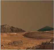
MastCam takes color, multispectral color, and stereo images as well as high definition video views of the Martian surface and atmosphere. Mastcam images can be used to observe clouds, dust raising events, properties of suspended aerosols and eolian transport of fines, to track optical depth by observing the Sun and to perform sky photometry.
MastCam Instrument Description Catalog Document
Mastcam Data Descriptions:
Raw Image (EDR IMG) Data Set Description Catalog Document
Raw Video (EDR VID) Data Set Description Catalog Document
Raw ZStack (EDR Z) Data Set Description Catalog Document
Reduced Image (RDR IMG) Data Set Description Catalog Document
Reduced Video (RDR VID) Data Set Description Catalog Document
Reduced ZStack (RDR Z) Data Set Description Catalog Document
Raw Video (EDR VID) Data Set Description Catalog Document
Raw ZStack (EDR Z) Data Set Description Catalog Document
Reduced Image (RDR IMG) Data Set Description Catalog Document
Reduced Video (RDR VID) Data Set Description Catalog Document
Reduced ZStack (RDR Z) Data Set Description Catalog Document
