- Observe and characterize the circulation of the planetary atmosphere, provide limits on atmospheric composition, and determine the wind velocities in the regions observed.
- Map the radial and azimuthal distribution of material in the ring plane; search for new rings.
- Obtain global multi-spectral coverage of all satellites; establish rotation rates and spin axis orientations, study the surface morphology of Triton at spatial resolutions less than 2 km; search for undiscovered satellites.
- Provide support images to assist other onboard investigations in their data reduction

Instrument Characteristics
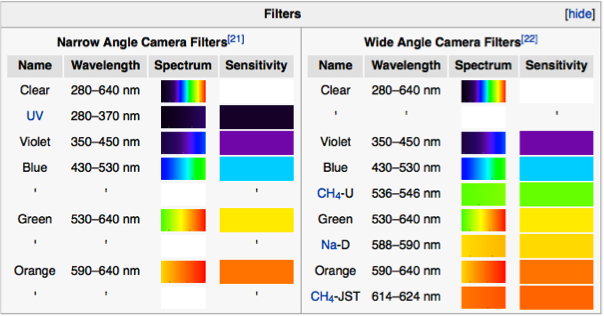
ISS consisted of a narrow angle slow scan video camera (1500 mm narrow-angle f/8.5 lens) with its field-of-view nested in the view of a lower resolution (200 mm wide-angle with a f/3 lens) wide-angle camera. Each camera had an 8 aperture filter wheel mounted in front of the camera that was stepped by sequences built into the command file sent up to the onboard computer. Limitations of computer memory and the fact that the videos were red-blind produced a data set with considerable dynamical content but limited vertical information (no strong CH4 filter images).
ISS Science Objectives
References Helpful in Scoping the Mission
Mission Description
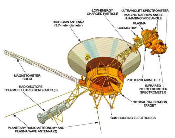
Spacecraft Description
Spacecraft Description
The ISS Data
Instrument Description
The data and supporting documentation are located in the imaging node
Jupiter Data
Raw data (ERDs) are available at the Cartography and Imaging Node
Processed data are available at the Ring-Moon System Node
Processed data are available at the Ring-Moon System Node
Saturn Data
Raw data (ERDs) and calibrated data (CDRs) are available at the Cartography and Imaging Node
Processed data are available at the Ring-Moon System Node
Processed data are available at the Ring-Moon System Node
Titan Data
Raw data (ERDs) are available at the Cartography and Imaging Node
Processed data are available at the Ring-Moon System Node
Processed data are available at the Ring-Moon System Node
Voyager 1, the close encounter, is located in volumes VG_0026 to VG _0030 and spans 1980-08-27 to 1980-11-15
Voyager 2 is located in volumes VG_0033 to VG_0037 and spans 1981-06-24 to 1981-08-25
Voyager 2 is located in volumes VG_0033 to VG_0037 and spans 1981-06-24 to 1981-08-25
Uranus Data
Raw data (ERDs) are available at the Cartography and Imaging Node
Processed data are available at the Ring-Moon System Node
Processed data are available at the Ring-Moon System Node
Neptune Data
Raw data (ERDs) are available at the Cartography and Imaging Node
Processed data are available at the Ring-Moon System Node
Processed data are available at the Ring-Moon System Node
Publications - A listing of team members to facilitate literature searches.
 PDS: The Planetary Atmospheres Node


